
Each row of your table becomes a pin. PinPop reads the address columns, looks up the coordinates of rows that have none with your Google Maps key when you say so, writes them into your table, and keeps the map in step with the sheet from then on. You need a working Google key first; see Get a Google Maps API key.
What your table needs #
- A header row on top and one row per place below it. An Excel table (Insert > Table) works best because new rows join it by themselves; a plain block of cells works too.
- Where each place is, in one of three forms: one column with the full address; address parts in separate columns (street, house number, city, state or region, postal code, country); or latitude and longitude, see Use latitude and longitude.
- A name column (optional) such as Name, Company, Customer or Store. It becomes the title of each popup.
PinPop recognizes common headers in English, German, French, Dutch and Spanish, for example Address, Street, City, Town, State, Zip code, Postcode, PLZ, Ort, Country and Land. Any other columns stay available for colors and popups.
Insert the map #
- Click any cell inside your table.
- Insert PinPop from the Add-ins menu. In a map frame that is already on the sheet, click Insert map from selected data instead. The line above it shows what PinPop will use, for example Selected: table Customers (240 rows).
- PinPop reads the headers and a sample of the values. When it is sure which columns hold the places, it draws the map right away. If the rows have coordinates, the pins show at once. If they have only addresses, the card Nothing to show yet waits for your click on Look up; see The lookups below.
Match your columns #
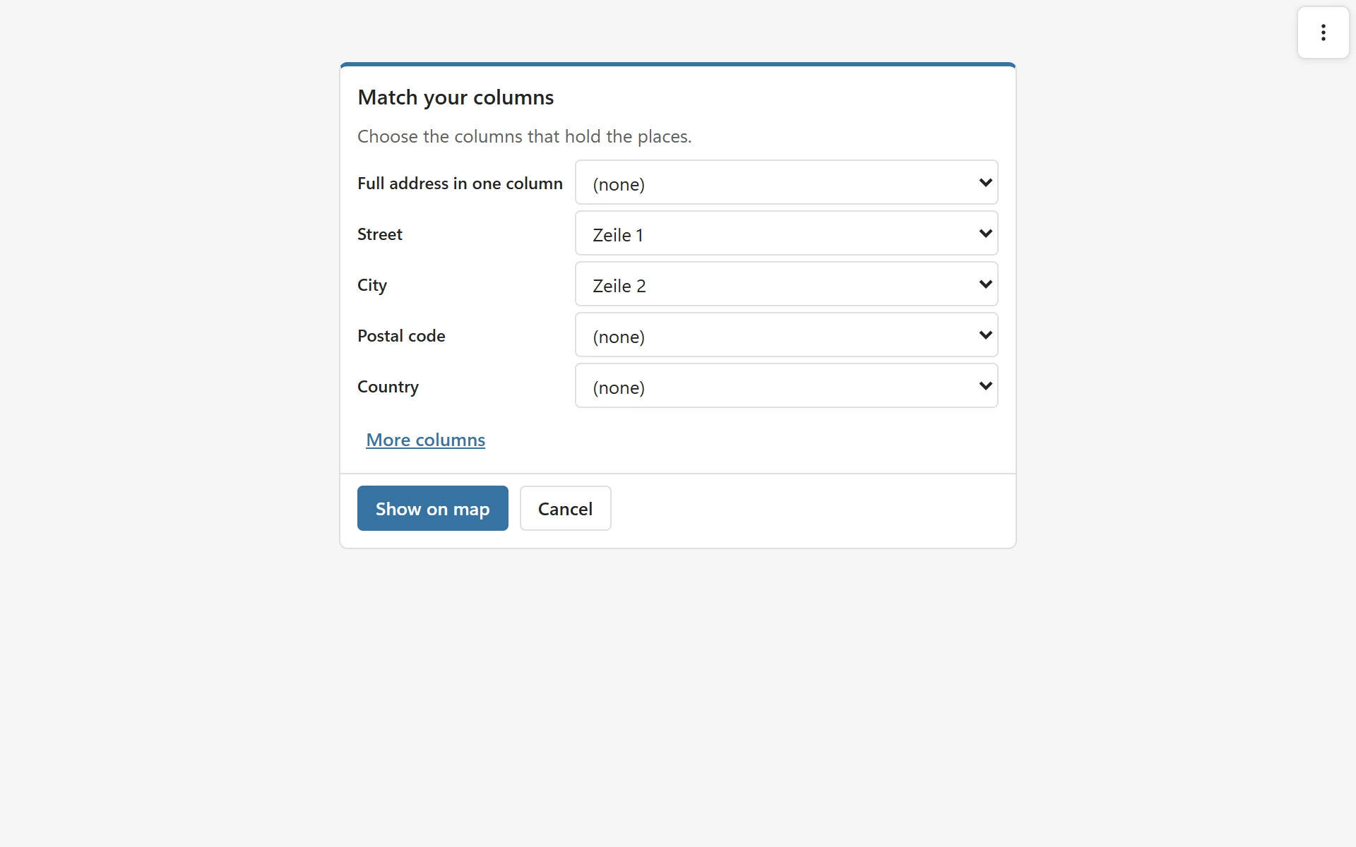
When PinPop cannot tell which columns hold the places, the step Match your columns opens with its best guess. It shows five fields: Full address in one column, Street, City, Postal code and Country. Choose a column for each field you have and leave the rest at (none). More columns adds Name, House number, Address line 2, State or region, Latitude, Longitude and Coordinates (one column). Then click Show on map. The step always has Cancel: on a new map it goes back to the first screen, and when you opened the step with Edit data link it goes back to the map.
PinPop remembers the columns by their header names, so the map keeps working when you move or insert columns. To change the choice later, open More options > Edit data link.
The lookups #
PinPop never starts the lookups on its own for a table you link. When the table has addresses but no coordinates, the card Nothing to show yet shows how many rows are waiting and a Look up button. Click it to start. The same holds after Edit data link.
Rows that have an address but no coordinates are looked up with your Google key, four at a time, each address once even when it appears in several rows. The progress shows in the frame, for example Looking up addresses: 120 of 600, with Cancel. PinPop writes the results into the table as it goes, so stopping keeps every row found so far. After Cancel, the line says, for example, Lookups stopped at 120 of 600. The coordinates found so far are in the table. Click Look up the rest on that line to finish the run, or later use More options > Look up 480 addresses. On a new map, the map opens with the first pins found and fits them, and the rest arrive while the lookups go on.
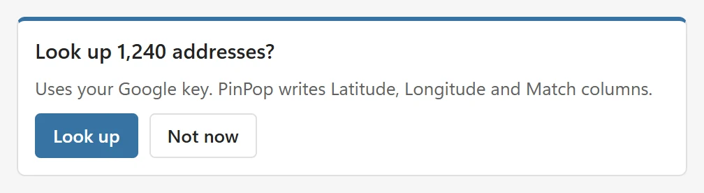
Above 500 new lookups, PinPop asks first. On a new map the card reads, for example, Look up 1,240 addresses? with the buttons Look up and Not now. On a map that is already showing, a line at the bottom asks the same with the same two buttons. After Not now on a new map, the card says Nothing to show yet and keeps a Look up button. On a map that is already showing, the line says No addresses were looked up. Look up is in More options when you are ready. The item there reads, for example, Look up 1,240 addresses.
When the run ends, PinPop says, for example, Found 238 of 240 addresses. 2 not found: see Issues. When every address is found, it says PinPop wrote coordinates for 240 rows. The free version looks up the rows inside its 50-pin limit only; see Plans and licensing.
Google is asked for the country of each row when the table has a Country column, otherwise for the region of your Excel language settings, as a hint. That hint never forces a result into one country.
The Latitude, Longitude and Match columns #
Before the first lookup, PinPop adds the columns Latitude, Longitude and Match at the right of your table. If the table already has columns with those names, PinPop uses them. Coordinates are numbers with 6 decimals. The Match column says how precise each answer is:
| Match | What it means |
|---|---|
| Exact | Google found the building. |
| Street | A position on the street, placed between known house numbers. |
| Area | The center of an area, such as a street, a postal code or a district. |
| Approximate | An approximate position, such as a town or a region. |
| Check | Google matched only part of the address. Check the row. |
| Not found | Google found no place for the address. |
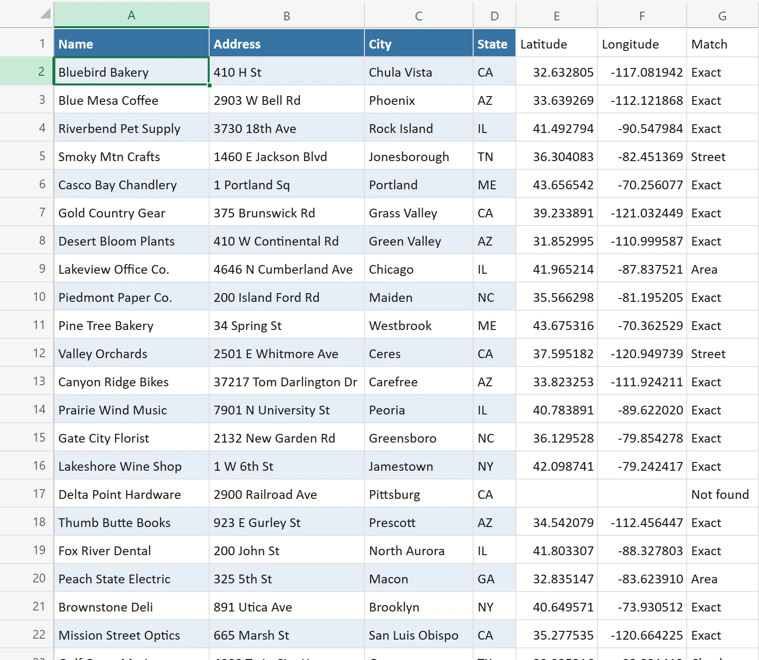
Rows marked Check and Not found are listed in More options > Issues; click one to select its cell. How to fix them is in Some addresses are not found or wrong.
A plain block of cells needs empty cells at its right for the three columns. If they hold data, PinPop says so; make room, or turn the block into an Excel table.
After the first run #
- Once you have clicked Look up (or answered Look up to a question) for a map, PinPop looks up later address edits by itself, within a few seconds and in one batch. Start with a sample counts as that yes.
- Only rows whose address text really changed are looked up: a new row, a typed new address, or an address you edited after it was looked up. Other rows stay as they are.
- Before that first yes, an edit only asks. A map that is showing asks with the line at the bottom, a new map with the card.
- Coordinates you type yourself are never overwritten. See Filter the map for filters and Look up all addresses again to look up everything again.
Good to know #
- A protected sheet still shows the map. PinPop writes coordinates only into cells the protection leaves unlocked, and a banner says so.
- A read-only workbook shows the map, but coordinates cannot be saved.
- Hidden rows (filters) are left off the map; merged cells are read as if the value filled every cell; the total row of a table is ignored.
- PinPop reads up to 50,000 rows of one table.